|
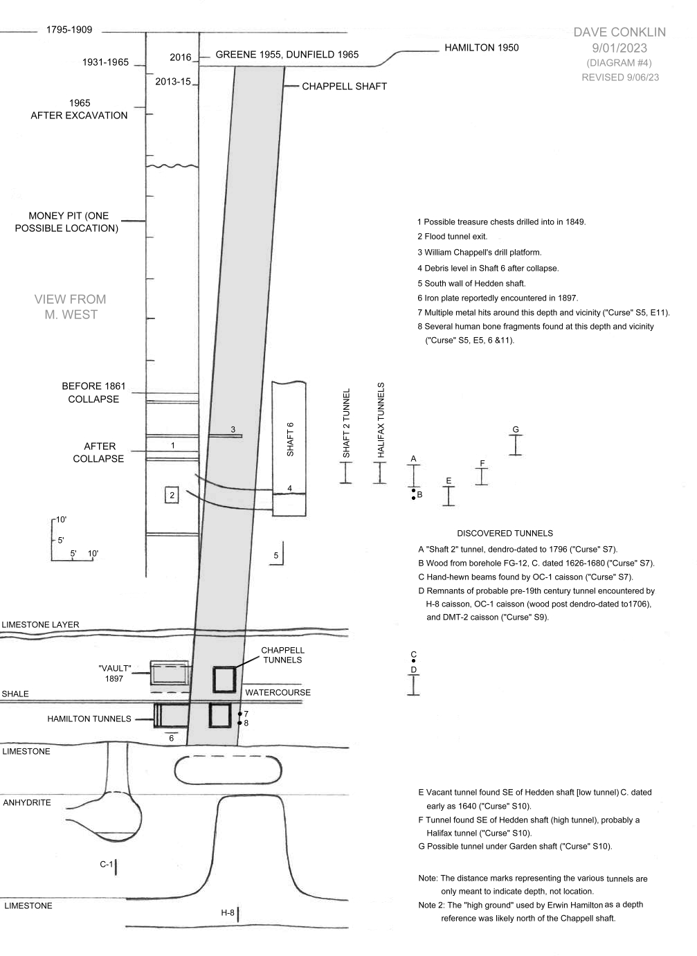
Dave’s Oak Island page 2/07/26: For the second time, my Oak Island page grew very long. I shortened it once back in 2019 by cutting a bunch of the "fat." This time, I decided to simply archive the page, so to speak, and start anew, with the initial focus being on my most relevant contributions. The original page is now here: Oak Island - theory. So from the start of the show, "The Curse of Oak Island," back in 2013, I attempted to satisfy my curiosity as to what the subsurface topography actually looked like under the Money Pit. This was back before any seismic study or muon tomography, of course, when all one had to go on were books, a few internet articles, old Oak Island documents, and the drilling operation on the show. The end result was the diagram below. Even today, I don't think I could improve on it much, and I have a lot of confidence in its accuracy, in general. |
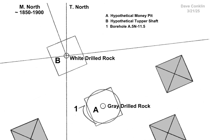
Last spring (2025), I got the idea that the money pit might have been marked by a stone, discovered by Fred Nolan I believe, known as "gray drilled rock." My theory did not pan out, though, as I came to the conclusion that the Garden Shaft (upper right of the diagram) and a shaft located off its southwest corner were most likely two shafts sunk by the Oak Island Treasure Company in the 1890s. The gray drilled rock would be the same area where the drill hit an air pocket that sent a blast of air and water up and out of the drill pipe in borehole AB-13 in S9, E10 of "Curse." The reason I am including the following diagram is that later on, I discovered a drill pipe, A.5N-11.5, that deviated in such a way as to mimic my hypothetical money pit. It could very well be a coincidence, of course, but it is unusual, I think, for a drill to deviate with such a constant curve. It should be noted that my position for the gray drilled rock was based on the Restall map. Steve Guptill has placed the rock 6' west of where the Restall map suggests it was, close to the surface position of the previously mentioned borehole, A.5N-11.5, with about a 3' margin for error, and it stands to reason that Fred Nolan probably surveyed it at some point, so maybe there is another map I am not aware of. |
|
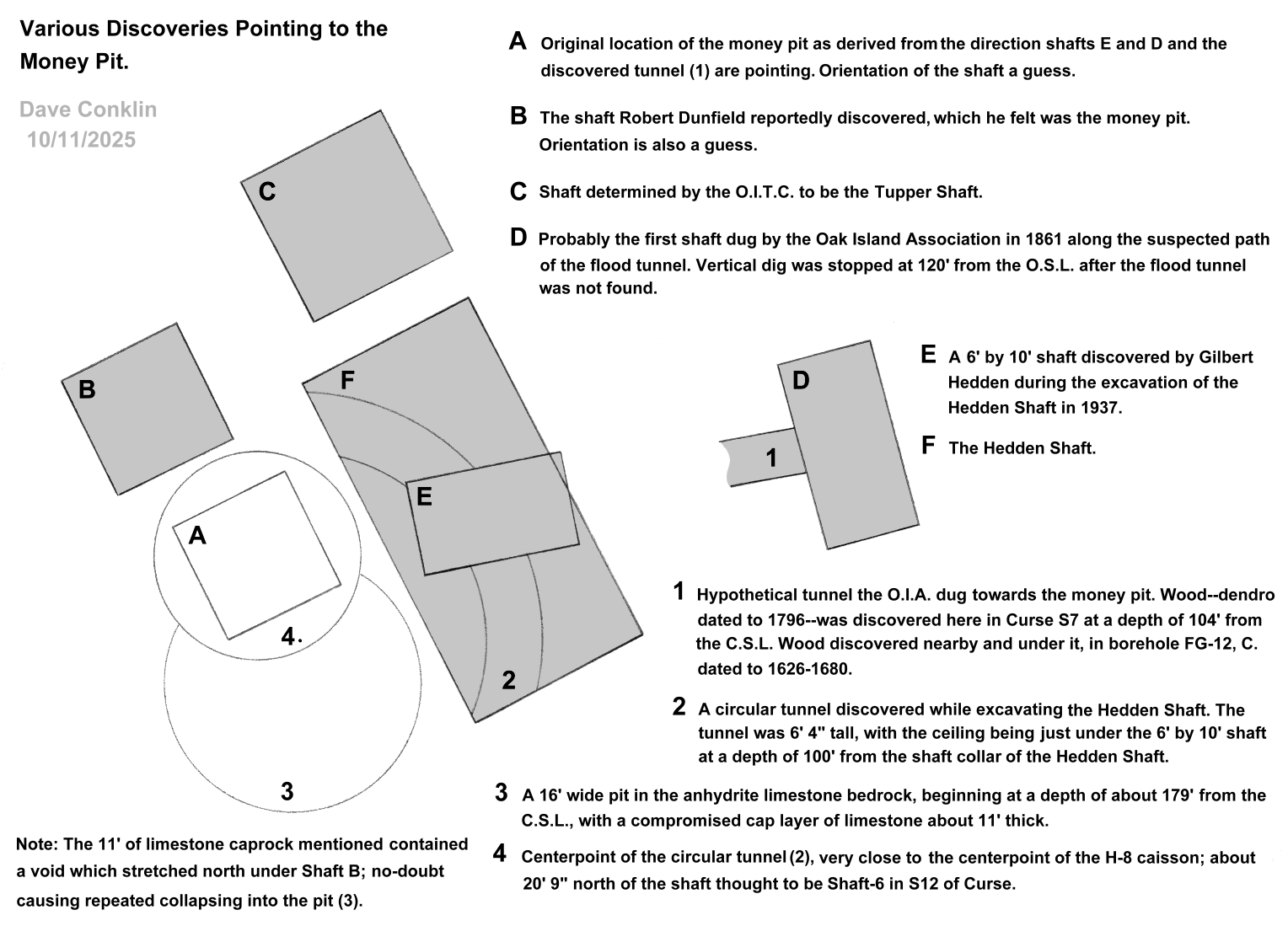
I created the following diagram last fall to fill an "information gap" regarding some of the things that have been discovered recently and in the past that might point to the Money Pit, that is - the classic location of the Money Pit. Bear in mind that there are a couple shafts that have been discovered near the Money Pit, one to the south and one to the west, that are not depicted. And the show keeps altering the orientation of that shaft north of the Hedden Shaft (the one labeled "C" on my diagram). As you can see, there seems to be two locations that everything points to, one about 6' 6" or so from the other. I have come up with a theory about all this since drawing the diagram, which is: The Money Pit was originally centered around the same point as the center point, labeled "4" in the diagram, for the semi-circular tunnel discovered by the Hedden Shaft; and then 45 years after the Onslow Company ceased their operation, when the Truro Company began their operation, the Money Pit was shifted about 6' 6" north. One can only speculate how this happened. In any event, the shift did not stop John Pitbladdo from finding a silver coin, if there is truth to that whole story. It wasn't until 1863, then, that the Oak Island Association finally rediscovered the exact centerpoint of the Money Pit, by which time most of the shafts in the immediate vicinity had already been sunk. The circular tunnel was then dug around the Money Pit's perimeter by the OIA, or perhaps a few years later by the Halifax Company. |
|
5/08/26: Finally, if nothing else, I think we can pinpoint with some degree of confidence exactly where the original Money Pit was located. Is it a treasure map? No, but kind of cool to be able to point to place and say, this is where the Money Pit probably was, and not be resorting to wild speculation. The breakthrough came with the sinking of a caisson dubbed Karma-1 during season 13, episode 17 of “Curse.” A large steel panel is brought up from about 155’ from the caisson, which was centered close to the south-east corner of the Chappell Shaft’s original surface location. The metal was most likely part of the shoe belonging to the Chappell Shaft, thus proving the shaft did not deviate northward nearly as far as depicted in various diagrams. Going all the way back to season 5, episode 10: Jack Begley is washing the spoils from the 156’ level in the H-8 caisson and runs out of water. The spoils table contains a few beams from the Chappell Shaft, indicating that at least a small portion of the 60” wide caisson was still encountering the Chappell Shaft at 156’. Armed with these facts, I created the following diagram, also assuming that the centerpoint of the semi-circular tunnel discovered by the Hedden Shaft is also the centerpoint of the original Money Pit, as re-discovered in 1863. The result was a near perfect match with a couple scribbles--in the papers John Lewis collected--depicting a semi-circular area inside the Chappell Shaft thought to be the perimeter of the original Money Pit. One of the scribbles was accompanied by a note: “See M. Chappell’s note re 113 ft level.” I have never seen the referenced note, but I am in setting the two sketches in my diagram for reference purposes. It is a busy diagram, but any serious Oak Island enthusiast should understand what is going on. Beyond the Chappell Shaft evidence and the circular tunnel is, of course, the human bones and other items (spike, leather, hand cut wood, pottery) brought up by the H-8 borehole and caisson, and the Geotech results of multiple metal hits surrounding H-8 (Curse S5, E11). Side note: I didn’t notice until I was well into the editing process that I fudged the “3-D” diagram of the Money Pit and Chappell Shaft . . . slightly, and it could stand to be re-drawn; but it would not change anything significantly it I did, so, it is what it is. |

|
A lot of details to go with this one, but we will start with the simple explanation: It looks as though the Money Pit was shifted north about five feet when the Truro Company revisited the Money Pit in 1749. Given some 45 years had passed since the last dig, it isn't too hard to imagine reasons why this occurred. The exact location of the original Money Pit was then rediscovered in 1863, after which a circular, or semi-circular, tunnel was constructed around it. The perimeter of the Money Pit would later be discovered by the Chappell Shaft in 1931, and the circular tunnel discovered by the Hedden Shaft in 1938. Now the details: In 1863, the actual center of the Money Pit was reportedly rediscovered when a “hard bottom” was discovered at 108’ with a hole on the east side going down. The Money Pit was also reported to have deviated towards the east, and I have included that assertion in my diagram. But--and assuming we do have the exact location of the original MP, as it is where so many things seem to be pointing to--whatever the hard bottom they found was composed of, it was not the absolute bottom, as evident by this statement by William Chappell made during the late summer of 1931 in regards to the Chappell Shaft, “I am convinced down to 150 feet at least, one end of your pit was over the edge of what was once an open chamber.” But in that regards, here is something to consider: If the Money Pit began life as a sinkhole going down to considerable depth, the hard bottom at 108 feet might be simply the extent at which the hole was originally excavated, with a later collapse--between 1909 and 1931 perhaps--collapsing the hard bottom--composed of material from the original collapse that created the sinkhole--and converting it into loose material. Seasoned Oak Island researchers will notice I have made some assumptions and speculations, one being the assumption that the MP was first cribbed in 1803, but I don’t know that to be absolute fact. Also, I have drawn all the old shafts (1803-1850), Money Pit included, based on where and how I think they were probably originally constructed. It should be noted, however, that a visitor to Oak Island in 1857 reported seeing the Money Pit and two surrounding shafts, all about 8’X12’ (double the sizes depicted). The two surrounding shafts he witnessed at the time were most likely the Tupper Shaft and the Fanny Young Shaft. You will notice I have designated the shaft that the present Oak Island team always referred to as Shaft 6 as Shaft 2. I never could understand why they were so sure it was Shaft 6. It is not located or positioned in any way like the descriptions of Shaft 6, and always looked to me to be a much better candidate for Shaft 2. And, of course, just because the wood doesn’t carbon-date as very old doesn’t mean the shaft could not have been re-cribbed at some point. And on the flip side of that, my own personal hunch is that some of the carbon-dating results they are getting back for various shafts and tunnels at the Money Pit are simply reading older than the wood actually is, for some reason. You will notice I labeled the Tupper Shaft (the shaft I think was probably the Tupper Shaft) as “#4” rather than “#3.” That is because an article published in the 10/18/1862 issue of the Liverpool Transcript, written by J. B. McCully, mentions a shaft dug in 1849 before the stone drains were found, with the Tupper Shaft coming after the drains were discovered. The former was reportedly dug somewhere 20 feet from the money pit before water was encountered at 94’. I figure it was probably filled in not long after it filled with water, joining Shaft 2 in the “obsolete shafts club.” So the H-8 caisson must have come down right along the north side of the east-west Chappell Tunnel, rather than the south side. Makes one really wonder what might have been lost in all those spoils brought up during the sinking of the Chappell Shaft and subsequent tunneling and sideways drilling. Something to keep in mind: The fact that William Chappell’s drill platform was discovered at the same depth as it was originally constructed suggests that the sinking of the ground at the Money Pit--estimated at 8 feet between 1909 and 1931--went down to considerably depth. Therefore, it stands to reason that both the semicircular tunnel and 6X10 shaft found in the Hedden Shaft could also have sunk. In other words, the 6x10 probably stopped at about 100’ from the original surface level when constructed, and the floor of the tunnel, then, was probably somewhere around 106’ 4” from the original surface. And the hard bottom found at 108’ in the Money Pit in 1863, then, should have been discovered at 108’ by the Chappell Shaft—if the hard bottom still existed. And, yes, this sinking-ground deal can be some “brain-stressing” stuff sometimes. Season 13 of “The Curse of Oak Island:” I once pointed out in earlier post (2023) that, of all the artifacts that have been found in the Money Pit, none have so far predated the 18th century--in any definitive way. However, I missed something: the stone shot discovered in S8, E19 while the spoils from an earlier borehole were being searched. The borehole was sunk somewhere near C-1, but I never caught the name/coordinates of it, if it was ever mentioned. At any rate, this season has brought forth more evidence that the original deposit made in the Money Pit might have, indeed, predated the 18th century: First, the Pitbladdo coin, then no less than two more stone shots found back-to-back in caissons separated by some 30 feet (Peacock-1, S13-E21 and MS-1, S13-E22). I mean, sure, the items could have arrived on the island much later, but who would be walking around with a bunch of cannon shot in their pockets that had become obsolete a hundred years prior? And wow!, 15 episodes just to discover how much dirt there was underneath a rock? But don’t get me wrong; it’s not that I want the team to go tearing into archaeological sites. But I do think the season could have been condensed into about the half the episodes that actually aired. At least for me, it could have. So, I had this thought a few months back; I haven’t mentioned it out loud until now, because I would, of course, never get any credit for it otherwise, let alone any thanks, if someone took it to heart. The idea, this time, is the self-tunneling metal-detecting snake. Sounds scary, but what I had in mind was something resembling an oversize endoscopic with a pin-pointer metal detector in its nose that could be sent down into those “solution channels” to search for metals. I’m envisioning a nose cone that can oscillate, much like a jack hammer, for tunneling capabilities. The catch is, the entire front end of the snake, including the nose cone, would have to be non-metallic so as not to interfere with the pin-pointer, but they make some pretty tuff plastics nowadays. The pin-pointer’s signal would, of course, need to be sent back through the tube by wire to the surface before being converted to an audio signal. The position of the pin-pointer would be tracked by a gyroscope positioned a little ways back on the tube. Of course, my idea completely depends on the notion that at least some of the solution channels near the Money Pit contain nothing but water, with only loose silty material at the bottom. If they are filled to the brim with dense mud, then my idea is a “washout.” No pun intended. |
HOME
mysteries, commentary, sci-fi